Showing posts with label Indian Environment Reports. Show all posts

Friday, August 22, 2025

Glacial Lake Outburst Flood (GLOF) And The Kedarnath Disaster In India

On June 17, 2013, a major disaster struck one of the country's most sacred destinations - the holy pilgrimage site of Kedarnath. The town was almost washed away, with thousands drowned, injured, and many gone missing in the raging floodwaters that swept through the town. The cause of this disaster was a glacial lake outburst flood (GLOF) involving the Chorabari Lake. The frightening news is that scientists predict that the chances of such GLOFs will rise in the future, primarily due to global warming-induced climate change.

Here is a detailed post on the term and how and why such events can multiply in the future.

What Is A Glacial Lake?

moraine-dammed glacial lake

A glacial lake is one whose formation is associated with a glacier or glacial activity. Most glacial lakes are formed when glaciers retreat and leave behind the meltwater filling the depressions eroded by glacial activity over time. Depending on how the natural dams that withhold water in the lakes are formed, such lakes can be moraine-dammed, ice-dammed, bedrock-dammed, or landslide/avalanche dammed.

The Lake That Died

The Chorbari Lake was a moraine-dammed glacial lake of untamed beauty at the foot of the Chorabari Glacier in Uttarakhand, India. It was located at an elevation of 3,960 m, about 2 km upstream of Kedarnath, and was part of the Mandakini river basin.

The lake, glacial in origin, formed from meltwater at the mouth of the Chorabari Glacier. However, over time, it became cut off from the glacier as the glacier retreated due to warming temperatures induced by climate change. Deposits between the lake and the glacier further isolated it. A moraine at the end of the lake, deposited in the past due to glacial activity, acted as a natural dam holding the lake's waters in place. The lake had a length of 250 m and a width of 150 m and was around 15 to 20 m deep. Rainwater and snowmelt then became the water source in the Chorabari Lake, whose water volume varied with seasons and changing precipitation levels each year. 

Another interesting fact about the lake is its connection with Mahatma Gandhi. A part of his ashes was immersed in the lake's waters, giving it the name Gandhi Sarovar. Because of this association with Gandhi, people would often trek to see the lake.

The Fateful Day

Glacial lake outburst flood

In June 2013, Uttarakhand received incessant rainfall, which was estimated to be 375% of what it normally receives during that time of the year. The rainfall caused the Chorabari glacier to melt in places and become unstable. The Chorabari Lake was already filling up with rainwater, which put immense pressure on its natural moraine embankment. The lake's level rose by 7 m or 23 feet during this time!

On June 17, an avalanche in the glacier triggered by incessant rain caused the ice with rocks and other debris to slide into the Chorabari Lake. This sudden rise in volume was too much for the moraine dam. It crumbled and the entire lake emptied itself downstream, carrying with it around 262 million litres of water, massive boulders, and other debris. Within 5 to 10 minutes, the Chorabari Lake was empty. The lakewater entered the Mandakini, swelling it up and lashing its fury on the towns that lay below.

Over 6,000 people died, and many went missing forever. Of course, there is no mention of the many animals that were wiped out as well. 

The Beginning Of The End?

In the aftermath of the disaster, Kedarnath was secured by a three-tiered wall behind the temple, strengthened embankments of the Mandakini River, and then rebuilt. 

The Chorabari Lake died—today, it is just a trickle of water flowing through the broken embankment area. Scientists predict that it will take at least a century before the lake fills up with water again. This will only happen if the embankment is plugged again by some event like a major landslide or avalanche. 

Despite this threat being eliminated, other lakes in the region could burst in the future as more and more new such lakes are to form as glaciers retreat and leave them behind. 

The root cause behind all this is global warming-induced climate change. It is causing glaciers to retreat and unpredictable weather events like excessive rainfall and snowstorms to become more common. 

So, while the Kedarnath Valley is safe from the Chorabari Lake for now, GLOF's related to other lakes, river flooding due to excessive rainfall, major avalanches, and earthquakes all threaten the future of this popular pilgrimage site.

Hence, it is important for authorities to reduce the anthropogenic impacts on the valley as much as possible to ensure that any future disasters have minimal impact on lives.

Not just the Kedarnath Valley but the entire stretch of the Himalayas is currently facing the risk of a GLOF. Millions of lives are at risk. As people worldwide contribute to climate change, the world as a whole will be responsible for such tragic events in the coming times.

Read more:

https://dialogue.earth/en/climate/death-of-chorabari-lake/

https://eos.org/articles/millions-in-india-vulnerable-to-glacial-lake-floods


Tuesday, February 20, 2024

Does India Need Its Own Red List Of Threatened Species?

A beautiful Gond art painting. Image credit: Vanam Art.

In India, whenever we want to know about the conservation status of a species, all we do is go to the IUCN Red List Site, enter the name of the species, and get the needed details. If we are even lazier, we search for the Wikipedia entry on the species, and there, on the right side of the page, is the column showing the species' conservation status as per the IUCN Red List. However, only less than 10% of the more than 2 million described species on Earth have been assessed for the Red List! It means that the conservation status of over 90% of the world's species still remains to be evaluated by the IUCN. Many such species might be on the brink and even go extinct before we have the chance to launch efforts to conserve them. To overcome this lacunae, we need more detailed and widespread research and assessment of species. One of the ways to bring that about could be to create country-specific Red Lists. Many countries, like the United States, Australia, Sri Lanka, the Philippines, and others, have already produced such lists. So, why not have our own Indian Red List? A list specifically catering to species that call India home? That way, we can get a more comprehensive list of our species to understand their conservation status and take well-targeted actions to conserve them.

The idea of an Indian red list or threatened species list is not brand new but has been floating around for quite some time. I only learned about it recently at a conference where a wildlife biologist giving a presentation on a lesser-known species mentioned the urgent need for India to create such a list to account for many species found in India that the IUCN Red List has not assessed.


When searching the internet, I also came across this 2011 Deccan Herald report, which was about India launching a mission to create a country-specific endangered species list. Initiated by the Environment Ministry of India, the aim was to create two separate red lists for plants and animals and to release the same during the 2012 COP-11 to be held in Delhi. The species would be evaluated using a model similar to the IUCN assessment model, and the task would be performed by various organisations, but the ultimate responsibility of verification and publication would lie with the Botanical Survey of India and the Zoological Survey of India. The reason to create such lists would be to bring to the forefront all species that do not receive conservation attention but urgently need protection. It would be a comprehensive list that would guide further conservation research and education in India.


However, over a decade later, I could not find any further reports on such lists created by searching online. Even today, thousands of species of plants and animals found in India remain out of the limelight, with many possibly on the verge of extinction, but we are hardly aware of the same. Can India's own Red List help improve the status of such species? If so, how and when can the project be executed? But most importantly, the question is, "Is India ready to have its own Red List.?"

Sunday, January 28, 2024

Where In India Are The Rhinos?

One-horned rhino in Kaziranga National Park, Assam.
One-horned rhino in Kaziranga National Park, Assam. Image credit: Anuwar ali hazarika via Wikimedia Commons.

The one-horned rhinoceros, a magnificent species, is also called the Indian rhinoceros, and rightly so, given that India houses more than 80% of the species' current population of 4014 as of 2022. Once distributed across a larger range from the Indian subcontinent to parts of China and numbering several thousand, today, the "Vulnerable" classified one-horned rhino suffers from a multitude of threats and has disappeared from large parts of its range. In India, too, the species was on the verge of vanishing before stringent actions were implemented to save it. A lot of praise goes to the Indian state of Assam, which houses nearly 85% of the country's rhino population of around 3,300. So, here are the places where you will find the most rhinos in India as per the State of Rhino Report 2022, released by the International Rhino Foundation.

Kaziranga National Park, Assam - 2,613 rhinos

Rhino in Kaziranga, Assam
Baby Rhino with mother in a marshland of Kaziranga National Park, Assam. Image credit: RAJEEV BASUMATARY via Wikimedia Commons

Assam's Kaziranga National Park and Tiger Reserve, also a UNESCO World Heritage Site, has performed exceptionally well in terms of one-horned rhino conservation. Poaching of these animals was rampant in this park until about a few years ago when stringent measures were taken to curb the issue. A special task force was created, and the rangers were allowed to shoot-at-sight orders to bring down poachers to save rhinos. The park now has 223 anti-poaching camps, with guards toiling hard to ensure the safety of the park's VIP rhinos! All that obviously worked well, with the park reporting zero rhino poaching in 2022. 

Jaldapara National Park, West Bengal - 287 rhinos

Jaldapara National Park rhino
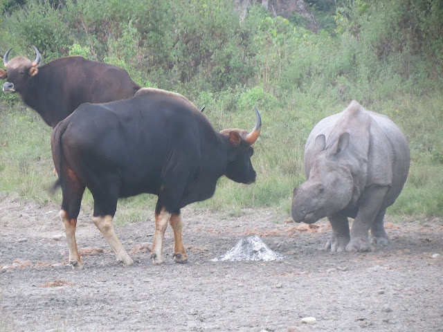
An interesting interaction between a rhino and two Indian gaurs at Jaldapara National Park, West Bengal. Image credit: Darshana Darshu via Wikimedia Commons.

The Jaldapara National Park recently went viral on social media as a scared and disturbed female rhino with calves in the park toppled a safari gypsy filled with tourists. Rhino moms are extremely protective of their babies and will not tolerate any nonsense from anyone that even slightly threatens their precious babies.

The park, located in the northern part of the state of West Bengal, is home to the second-highest Indian rhino population, with 287 rhinos. Recently, the state government has devised several strategies, including the expansion of the grasslands to further secure the home of the rhinos in and around the park.

Orang National Park, Assam - 125 rhinos

A rhino in the grasslands of Orang National Park.
A rhino in the grasslands of Orang National Park. Image credit: Nejib Ahmed via Wikimedia Commons

Another national park in Assam, the Orang, on the northern banks of the mighty Brahmaputra River, is turning out to be a secure home for the state's rhinos. No wonder that it is often called the "Little Brahmaputra." As of 2022, the park has a rhino population of 125, which is 24 up from the last count taken in 2018. 

Pobitora Wildlife Sanctuary, Assam - 107

A female rhino and calf at Pobitora
A female rhino and calf at Pobitora Wildlife Sanctuary, Assam.

Next up is Pobitora Wildlife Sanctuary, also from Assam, with 107 one-horned rhinos. The sanctuary is located in the suburbs of Assam's capital city, Guwahati, and is a haven for wildlife-loving residents of the city as well as numerous visitors. The 2022 number was five more than the 2018 count. The sanctuary is known to offer excellent rhino sightings to visitors and is a must-visit for those touring the state.

Gorumara National Park, West Bengal - 52

A rhino at Gorumara National Park, West Bengal.
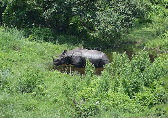
A rhino at Gorumara National Park, West Bengal. Image credit: Dr. Satyabrata Ghosh via Wikimedia Commons.

Another protected area in northern West Bengal, the Gorumara National Park, provides a good habitat for the rhinos. Together, the Jaldapara and Gorumara host the entire population of rhinos in the state, but the state government now plans to introduce rhinos to two more protected areas, the Buxa Tiger Reserve and a small reserve in Cooch Behar.

Manas National Park, Assam - 40

A one-horned rhino at Manas National Park, Assam. Image credit: Gitartha.bordoloi via Wikimedia Commons

Another UNESCO World Heritage Site in Assam, the extremely beautiful Manas, is home to 40 rhinos as of 2022. The park's rhinos were all wiped out by 2005 due to intense poaching, but a successful reintroduction program leading to the translocation of rhinos to the park in several batches starting in 2006 helped have a stable rhino population in Manas again. 

Dudhwa National Park, Uttar Pradesh - 40

rhino in dudhwa, india
A reintroduced rhino in Dudhwa Tiger Reserve, India. Image credit: A. J. T. Johnsingh, WWF-India and NCF, via Wikimedia Commons.

A new state's entry on the list comes with Dudhwa National Park. The beautiful park, located along the India-Nepal border in Uttar Pradesh, had lost all its rhinos due to colonial-era hunting and then poaching until rhinos were reintroduced here from Assam in 1984. Initially, five rhinos were introduced, and the population has since grown gradually.

India's efforts in saving the rhinos deserve applause. Poaching has been largely curbed in the country's rhino habitats by the strict implementation of the law. However, given the high demand for rhino horns in the illegal market, authorities need to be on constant alert to protect the rhinos against this threat. Habitat loss, degradation, fragments, and human-rhino conflict cases are now the biggest threats to this endangered species in India, and a lot of effort is needed to protect the growing population of these massive, majestic beings in the country.

Tuesday, December 5, 2023

Top 10 Indian States By Mangrove Cover

A Bengal tiger in the Sundarbans mangrove forest of West Bengal
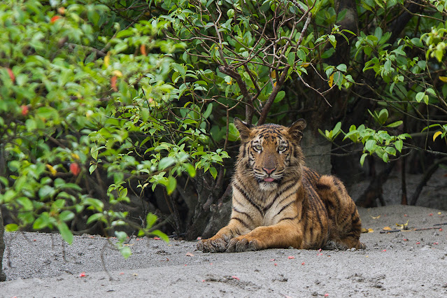
A Bengal tiger in the Sundarbans mangrove forest of West Bengal. Image credit: Soumyajit Nandy via Wikimedia Commons.

Mangroves are vital to coastal security. Mangrove forests act like a barricade along the coast, protecting inland areas from cyclones, tidal action, etc. This unique vegetation type, adapted to survive in the brackish environment with the help of special adaptations like pneumatophores, also serves as nurseries for aquatic fauna and a number of terrestrial fauna, including the Bengal tiger in the Sundarbans. Fortunately, India is blessed with significant mangrove cover along its coastal areas in several states, with the list below depicting the six states with the most mangrove cover:

1. West Bengal - 42.33%


Sundarbans mangroves in West Bengal.
Sundarbans mangroves in West Bengal. Image credit: pxhere.com

West Bengal houses a whopping 42.33% of India's total mangrove cover, which is synonymous with the Sundarbans forest of the state. Located at the delta of the Ganga-Brahmaputra-Meghna rivers as they drain into the Bay of Bengal, the Sundarbans mangroves cover a massive area of 2,112 sq. km in the state and also extend further into neighboring Bangladesh. It is also the world's only mangrove area to house the Bengal tiger. The tigers of the Sundarbans are much talked about and the subject of many documentaries, films, stories, and scientific research.


2. Gujarat - 23.54%


Mangrove forest along the coast of Gujarat. Image credit: https://commons.wikimedia.org/wiki/File:Mangrove_Forest_Sindh.jpg


Gujarat boasts India's second-highest mangrove cover of 1177.27 sq. km, comprising 23.54% of the country's total. Unlike West Bengal, the state's mangroves are distributed across four coastal areas; the Kachchh region in the Kachchh district has 67.5% of the state's total mangrove cover; the Gulf of Kachchh region with 19.88% of the total cover; and Saurashtra and South Gujarat with 0.48% and 11.87% of the mangrove cover, respectively. For more details, visit here.


3. Andaman And Nicobar Islands - 12.34%


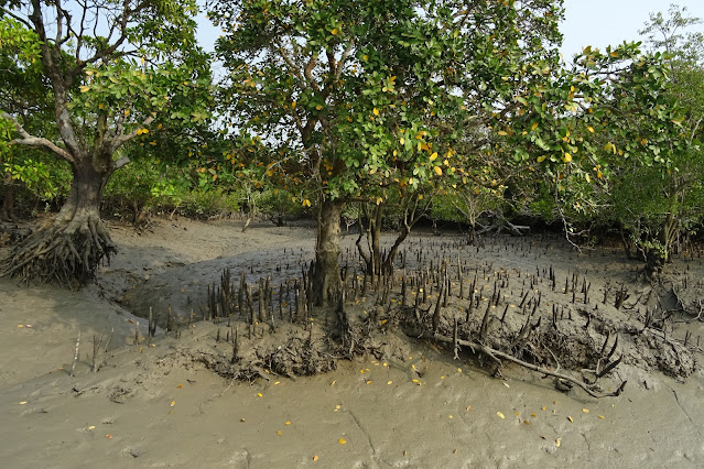
Mangrove plants in the Andaman and Nicobar Islands. Image credit: Sankara Subramanian via Flickr.com


This group of islands in India has a mangrove cover of around 616 sq. km, with the Andaman group having the bulk of 613 sq. km and the remainder in the Nicobar. The mangroves of this region cover 7.5% of the land area and are considered the best in India in terms of quality. The mangroves enhance the beauty of the islands and support rich biodiversity.


4. Andhra Pradesh - 8.11%


Although Andhra Pradesh has the fourth highest mangrove cover in India, around 404 sq. km, it constitutes only 0.9% of the state's total forest area. Most of the mangroves are found along the estuaries of the state's major rivers - the Godavari, Krishna, Pennar, and Vamsadhara, as these rivers enter the Bay of Bengal. Small patches of mangroves also occur in some other parts of the state's coast outside these estuary regions.


5. Maharashtra - 6.49%


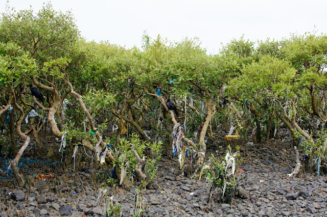
Trash-wrapped mangroves in Mumbai.
Trash-wrapped mangroves in Mumbai. Image credit: Alex Derr via Flickr.com


In 2012, Maharashtra became the country's first state to establish a dedicated wing to conserve the mangroves, and the effort bore fruit, with the state's mangrove cover increasing by 72% by 2022! Six coastal districts of the state, including the city of Mumbai, share this total mangrove cover of 320 sq. km. 


6. Odisha - 5.27%


Bhitarkanika mangroves. Image credit: https://commons.wikimedia.org/wiki/File:Bhitarkanika_Mangroves_Flora_and_Fauna_04.JPG

Odisha houses a mangrove cover of 258.98 sq. km, of which 80.43 sq. km is dense cover. The Bhitarkanika Sanctuary protects a significant section of this mangrove, while the delta regions of rivers like the Mahanadi, Subarnarekha, and others also have some mangrove cover. Altogether, four Odisha districts with mangroves include - Balasore, Bhadrakh, Jagatsinghpur, and Kendrapada.


Top 10 States In India By Mangrove Cover


  1. West Bengal - 42.33%
  2. Gujarat - 23.54%
  3. Andaman and Nicobar Islands - 12.34%
  4. Andhra Pradesh - 8.11%
  5. Maharashtra - 6.49%
  6. Odisha - 5.27%
  7. Tamil Nadu - 0.9%
  8. Goa - 0.52%
  9. Karnataka - 0.26%
  10. Kerala - 0.2%


Protecting India's existing mangrove cover and, wherever possible, allowing it to expand further along its historic range is vital to the country's coastal sanctity and biodiversity preservation. Some states have already taken the lead, while others are lagging behind. 

Saturday, March 3, 2018

What Is The Coldest Place In India?

The Coldest Temperature Recorded In India


Dras

Dras is a town in India’s Kargil District in the country’s northernmost state of Jammu and Kashmir. The town is located at an elevation of 10,990 ft and is regarded as the ‘Gateway to Ladakh’. It is often labelled as the coldest place in India. The lowest temperature of India of −33.9 °C was recorded here. The place experiences a continental climate with dry and cool summers which last from June to September. The average temperature at this time is about 23 °C. Winters last from mid-October to May and have temperatures averaging around −20 °C. Precipitation takes place mostly in the winter months and averages around 550 mm water equivalent of snowfall.


Leh


Another town in Jammu and Kashmir, Leh, is also known for its frigid winters with temperatures dropping as low as −30.6 °C. Leh was the former capital of the kingdom of Ladakh and its palace housed the ruling family of the time. The town is located at an elevation of 11,562 ft above sea-level. Leh experiences a cold desert climate with pleasant weather in summers (April to October) and extremely harsh winters between November and early March. Precipitation is very low with occasional snowfall in winter and an average annual rainfall of only 102 mm.

Is This The Coldest Place In India?


Although the above towns have recorded some of India’s lowest temperatures, the records in the India-controlled Siachen Glacier area are way lower. Subjected to territorial disputes between India and Pakistan, this area has witnessed skirmishes and wars between the armies of two sides for decades. Located near the 17,881 ft high Bilafond La and the 18,337 ft tall Sia La, this area has recorded temperatures as low as −55 °C. Blizzards blowing in this area have wind speeds higher than 250 km/h. Such extreme conditions claim the lives of many soldiers posted in this area to guard the borders of their own countries.


Wednesday, February 21, 2018

Where Is The Hottest Place In India?

Where Is The Hottest Place In India?


The hottest place in India is located in the state of Rajasthan. It is a town named Phalodi that is located in the state’s Jodhpur District. 

On May 19, 2016, Phalodi recorded a temperature of 51.0 °C, the highest temperature ever recorded in India. The figure crossed the previous record of hottest temperature in India which was 50.6 °C in Alwar, Rajasthan in 1955. 

Phalodi, a town noted for its large number of salt industries, is located in the Thar Desert’s buffer zone. The town has a generally hot and semi-arid climate and highly variable rainfall. March to October are extremely hot and temperatures routinely exceed 40 degrees Celsius from April to June. The average rainfall is about 254 mm with the rainy season lasting from late June to September.


Tuesday, September 26, 2017

The Elephant Population In India By State: Preliminary Results Of 2017 Elephant Census


The IUCN recognizes the Asian elephant (Elephas maximus) as an endangered species. The population of this charismatic species has declined by over 50% in the past 60 to 75 years. Indian forests are a vital habitat of the Asian elephants and about 60% of the global population of Asian elephants reside in the country.

In India, the presence of wild elephants has been recorded mainly in four regions in the country. These are :- 1. Northern region; 2. East-central region; 3. Northeastern region; and 4. Southern region.

A nationwide elephant census is conducted every five years in India. The most recent census of elephants in India has been conducted in 2017 and the preliminary results based on the “sighting-based direct count” method are out. According to the results, India’s total elephant population is 27,312 in 23 states of the country. The advanced results will be available to us once the figures from the more accurate indirect dung-count method are out.


When the preliminary result of the 2017 census is compared with the result of the 2012 census which estimated India’s elephant population to be between 29,391 and 30,711, it appears that the number of elephants in India has decreased over the years. However, according to experts, this might not be the case. During the 2012 census, different methods were used to count elephants in different parts of India and the efforts were not synchronized. Thus, duplication and errors could have given higher figures.

As per the 2017 preliminary elephant census figures, 55% of the elephant population of India is concentrated in the Southern region, mainly in the two southern states of Karnataka and Kerala. The Southern region has 11,960 elephants. The North-east region comes next with 10,139 elephants. This is followed by the East-central region with 3,128 elephants and the Northern region with 2,085 elephants. 


Also, as per the 2017 preliminary elephant census report, Karnataka has 6,049 elephants, the highest in the country. This state is followed by Assam with 5,719 elephants and Kerala with 3,054 elephants.


The table below mentions the state-wise distribution of elephants in India as per the preliminary results of the 2017 elephant census:


The relatively stable population of Asian elephants in India might appear to be a reason to rejoice. However, the fact is that human-elephant conflicts have dramatically risen over the past few decades. The clearance of forest lands to create space for human habitation and agriculture, and other developmental projects, have subjected the elephants of India to smaller habitats. Since elephants migrate in search of food sources, their movements between heavily fragmented habitats have brought them face to face with humans. This has often led to deaths of both humans and elephants. Poaching of elephants has also served as a serious issue affecting India’s wild elephant population.

Thus, an attempt must be made to end man-animal conflicts and poaching in India’s forests.

References:


Wednesday, August 2, 2017

Deadliest Earthquakes In India

India has a long history of devastating earthquakes. The fact that the Indian plate is constantly shifting and driving into Asia, is the primary reason behind most of the earthquakes experienced in the Indian subcontinent. Nearly 54% of the land in India is subjected to earthquakes. The UN and World Bank estimates that by 2050, nearly 200 million urban dwellers in India will be exposed to earthquakes and storms in India.

Here, we have compiled a list of the most deadly earthquakes experienced in India and the death toll figures represent only the casualties that happened within the territory of independent India.

1. 1905 Kangra Earthquake


The 1905 caused wanton death and destruction in the Kangra Valley of British India’s Punjab province (now Himachal Pradesh). The disaster happened on April 4, 1905, and killed over 20,000 people. Huge loss of property was also incurred when most structures in Kangra, Dharamshala, and Mcleodganj were damaged or leveled to the ground. About 53,000 domestic animals lost their lives. The hillside aqueducts that supplied water to the earthquake-affected area were also severely damaged.

2. 2001 Gujarat Earthquake


The 2001 Bhuj earthquake struck at 08:46 AM IST on January 26, 2001, India’s 52nd Republic Day. The earthquake that lasted for 2 minutes had its epicenter about 9 km to the south-southwest of the Chobari village in Gujarat, India. The earthquake claimed the lives of about 13,805 to 20,023 people, injured about 167,000 people, and damaged about 400,000 homes. Hundreds of villages were flattened and the city of Bhuj, located about 20 km from the epicenter, was completely destroyed. Several historical structures in the city were also damaged. In the capital city of Gujarat, Ahmedabad, nearly 50 skyscrapers collapsed killing many residents. Even the Bhuj Civil hospital was not spared by the earthquake. The earthquake can be labeled as the deadliest earthquake in India.

3. 2004 Indian Ocean Earthquake 


The 2004 Indian Ocean earthquake shook India as well as many countries along the coast of the Indian Ocean. It was the deadliest earthquake experienced in India and one of the world’s deadliest earthquakes. The epicenter of the earthquake was off the west coast of the Indonesian island of Sumatra. The quake triggered massive tsunamis that lashed on the shores of the coastal areas where they destroyed and drowned all that came in the path. Over 10,136 people lost their lives in India as per official estimates. The total death toll from the disaster that affected 14 countries was 230,000–280,000.

The Andaman and Nicobar Islands archipelago was the worst hit during this earthquake. It was reported that the Nicobar Islands lost nearly one-fifth of the population. Several islands were also submerged completely and the Trinket Island was divided into two. The earthquake also left thousands homeless in India and great damage to property was also incurred.

4. 1993 Latur Earthquake


On September 30, 1993, nearly 10,000 people lost their lives and over 30,000 more were injured when an earthquake jolted the Maharashtra state of India at 3:56 am local time. The districts of Osmanabad and Latur were the worst affected. Several villages were completely demolished. 

5. 1941 Andaman Islands Earthquake


Although this earthquake was one of the deadliest earthquakes in India, the timing of the disaster during the initial stages of the World War II led to the poor coverage of the immense death and destruction caused by the earthquake. The earthquake struck the Andaman Islands archipelago on June 26, 1941. It is reported that as many as 8,000 people lost their lives in this earthquake.

Below is a comprehensive list of the worst earthquakes in India with over 100 deaths in India: