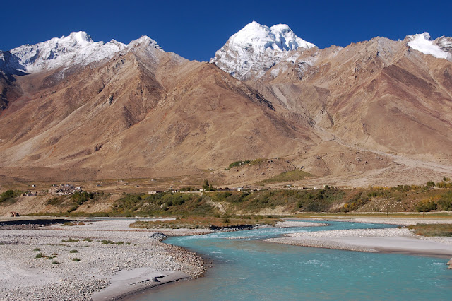
1. The Himalaya Range
The Himalayas are famous for hosting some of the Earth’s tallest peaks including the Mount Everest, the highest peak in the world. These mountains lie between the Tibetan Plateau to the north and the vast river plains of India to the south. The Himalayas are spread across five countries including India. The Himalayan mountains are India’s youngest mountains and greatly influence the climate pattern of the country. These mountains also have a profound effect on the Indian culture. More than 50 Himalayan peaks are more than 7,200 m tall. Many Indian rivers that are vital to the survival of millions of Indians originate from the Himalayan glaciers. The three tallest mountains of India, Mount Kangchenjunga (8,586 m), Nanda Devi (7,816 m), and Mount Kamet (7,756 m) all belong to the Himalaya Range.
2. The Karakoram Range
Another long chain of mountains, the Karakoram Range extends for about 500 km across five countries including Tajikistan, Afghanistan, Pakistan, India, and China. In India, mountains of this range lie in the Ladakh region. The Karakoram Range is the world’s second most glaciated region after the two polar regions. Six of India’s ten tallest mountains are part of the Karakoram Range with the 7,742 m tall Saltoro Kangri being the tallest among them. The Siachen Glacier located in the Karakoram Range is part of India and is the world’s second longest glacier outside the polar regions.
3. The Eastern Mountain Range or The Purvanchal Range
An eastern extension of the mighty Himalayas, the Purvanchal Range is found in north-eastern India where the range bends sharply to the south to continue along the eastern boundary of India with Myanmar. Several hill ranges like the Naga Hills, Mizo Hills, Patkai, etc., are part of this range. However, the Jaintia, Garo, and Khasi Hills are excluded from this range. The mountains of the Purvanchal Range are primarily composed of sandstone.
4. The Satpura Range
The Satpura Range extends from eastern Gujarat to Chhattisgarh. Together with the Vindhya Range, the Satpura Range dissects India into the two geographical regions of northern Indo-Gangetic plain and the southern Deccan Plateau. Important rivers of southern India like the Narmada and the Tapti rivers have their headwaters in this mountain range. At the eastern extreme, the Satpura Range merges with the hills of the Chota Nagpur Plateau. Large parts of the Satpura Range are covered by forests which house several threatened species like the Bengal tiger, dhole, gaur, sloth bear, and more. National parks like the Kanha National Park, Pench National Park, and other protected areas in the area help conserve the ecosystem of the Satpura Range. Several places of tourist interest like the hill stations of Pachmarhi and Amarkantak, wildlife-rich national parks, heritage sites, and more attracts both domestic and international tourists to the area. The 4,430 ft tall Dhupgarh peak is the tallest peak in the Satpura Range.
5. The Vindhya Range
A series of complex and discontinuous mountains, hills, plateau, and highlands in west-central India, are referred to as the Vindhya Range. Due to the broken and dispersed nature of the range, it cannot be treated as a mountain range in the truest sense. Currently, the Vindhya Range mainly refers to the escarpment running north of the Satpura Range and parallel to the Narmada River from Gujarat in the west to Bihar and Chhattisgarh in the east. The Vindhya Range has a very significant mention in the Indian mythology and history. According to ancient accounts, the Vindhya Range forms the boundary between the homeland of the Indo-Aryans or the Āryāvarta and the southern Indian natives. The 2,467 ft high Sadbhawna Shikhar is the tallest mountain in the Vidhya Range.
6. The Zanskar Range
The mountain range separates Ladakh from Zanskar in the eastern half of the northernmost Indian state of Jammu and Kashmir. The average height of the mountains of the Zanskar Range is 19,700 ft.
7. The Western Ghats
The Western Ghats or the Sahyadri is a mountain range running parallel to Indian peninsula’s western coast where it separates the Konkan coast, a narrow coastal plain in the west from the Deccan Plateau in the east. The mountain region is one of the world’s biodiversity hotspots and also a UNESCO World Heritage Site. 39 protected areas are part of the Western Ghats. The Western Ghats stretches from the Maharashtra-Gujarat border region south to Swamithoppe in Tamil Nadu near the southernmost tip of India. This mountain range covers an area of 160,000 square km and a length of 1,600 km. The average elevation here is about 3,900 ft. The Anamudi Peak in Kerala is the tallest peak of the Western Ghats. It has an elevation of 8,842 ft above sea-level.
8. The Eastern Ghats
The dissected range of mountains, the Eastern Ghats extend along the east coast of India from northern Odisha to Tamil Nadu. The Eastern Ghats are highly eroded mountains with major rivers cutting through them to drain into the Bay of Bengal. The Eastern Ghats roughly acts as the border between the Deccan Plateau to the west and the eastern coast including the Coromandel Coast to the east. The Eastern Ghats are also rich in flora and fauna and have several protected areas thriving with wildlife. The 5,545 ft tall Jindhagada is the tallest peak in the Eastern Ghats.
9. Aravalli Range
The Aravalli Range runs for a distance of 692 km from Delhi in northern India westwards to Rajasthan and finally ends in Gujarat. The 5,650 ft tall Guru Shikhar peak of Mount Abu is the tallest peak in the range. These mountains are the oldest fold mountains in India and have been eroded over time to result in the stubble of mountains we see today. The Aravallis currently are the source of many Indian rivers and host a rich diversity of flora and fauna, protected areas, hill stations, and heritage sites that attract many tourists to the area.


No comments:
Post a Comment