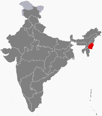
Where Is Manipur?
Manipur is located in northeastern India with Imphal as the state capital. The Indian state is bounded by Nagaland to the north, Burma to the east, Assam to the west, and Mizoram to the south. Manipur encompasses an area of 22,327 square km and houses a population of nearly 3 million. The Kuki, Naga, Pangal and Meetei peoples are some of the major ethnic groups living here. Manipur has a strategic location in India since it connects the Indian subcontinent to Southeast Asia, allowing Asian economic and cultural exchange between these two countries to take place.
Topology Of Manipur

Manipur’s landscape and topology can be divided into two distinct zones. There is an outlying area with rugged hills and narrow valleys and an inner stretch of flat plain. The central plain houses the famous Loktak Lake. The elevation of the state varies from 40 meters at Jiribam to 2,994 meters at Mount Iso Peak.
Hydrology Of Manipur

Manipur has four major river basins, the Manipur River Basin, the Yu River Basin, the Barak River Basin, and a section of the Lanye River Basin in the north. The Barak River that originates in the Manipur Hills is the largest river in the state. The Tuivai, Maku, Irang are its major tributaries. After the Barak River is joined by the Tuivai, it flows north where it forms Manipur’s border with Assam, and then enters Assam. Eight rivers constitute the Manipur river basin. These are the Imphal, Nambul, Chakpi, Khuga, Manipur, Sekmai, Iril, and Thoubal. These rivers originate from the hills surrounding Manipur.

Most of the mature rivers deposit their sediments in the Loktak Lake.
Soils Of Manipur
The soil cover of Manipur is of two main types. Red ferruginous soil is found in the hilly regions of the state and alluvial soil in the valleys. The soils in the valley also contain small rock fragments, sandy clay, loam, etc. The soil layer on the steep slopes of Manipur’s hills is quite thin since it is subjected to heavy erosion. However, the soil in the deltas and flood plains is thick.
Climate Of Manipur
Manipur enjoys a generally pleasant climate though days in winter can be quite chilly. The altitude of the state at an average elevation of 790 meters above sea level and the fact that it is surrounded by hills influences the climate of the place. In summers, maximum temperature can be as high as 32 °C while winters can have temperatures as low as the freezing point. Frost is common during winters while snow falls in the hilly regions of the state on certain occasions. January is the coldest month and July the warmest one.
May to mid-October is the rainy season when the state receives a very heavy amount of rainfall. The average annual rainfall is around 1,467.5 mm. The distribution of rainfall varies in different parts of the state.
State Symbols Of Manipur

State Animal: Sangai (Rucervus eldii eldii)

State Bird: Nongyeen (Syrmaticus humiae)
State Tree: Uningthou (Phoebe hainesiana)

State Flower: Siroi Lily
Protected Areas Of Manipur

Flora Of Manipur

Nearly 64% of the geographical area of Manipur (about 14,365 square km) is occupied by natural vegetation. Trees, bamboos and reeds, tall and short grasses constitute the different types of vegetation found here. Four types of forests are found in Manipur: Sub-Tropical Pine, Tropical Moist Deciduous, Tropical Semi-evergreen, and Dry Temperate Forest.
Orange, tea, coffee, orange, and cardamom are grown on the hill slopes of Manipur while rice is cultivated in the valley region. Wild forests found here are dominated by trees like teak, bamboo, cane, oak, pine, and uningthou.
Fauna Of Manipur

The fauna of Manipur includes the hoolock gibbon, clouded leopard, spotted linsang, slow loris, tragopan, Burmese pea-fowl, Blyths Tragopan, several species of deer, and more.
Manipur is located in northeastern India with Imphal as the state capital. The Indian state is bounded by Nagaland to the north, Burma to the east, Assam to the west, and Mizoram to the south. Manipur encompasses an area of 22,327 square km and houses a population of nearly 3 million. The Kuki, Naga, Pangal and Meetei peoples are some of the major ethnic groups living here. Manipur has a strategic location in India since it connects the Indian subcontinent to Southeast Asia, allowing Asian economic and cultural exchange between these two countries to take place.

Topology Of Manipur

Manipur’s landscape and topology can be divided into two distinct zones. There is an outlying area with rugged hills and narrow valleys and an inner stretch of flat plain. The central plain houses the famous Loktak Lake. The elevation of the state varies from 40 meters at Jiribam to 2,994 meters at Mount Iso Peak.
Hydrology Of Manipur


Most of the mature rivers deposit their sediments in the Loktak Lake.
Soils Of Manipur
The soil cover of Manipur is of two main types. Red ferruginous soil is found in the hilly regions of the state and alluvial soil in the valleys. The soils in the valley also contain small rock fragments, sandy clay, loam, etc. The soil layer on the steep slopes of Manipur’s hills is quite thin since it is subjected to heavy erosion. However, the soil in the deltas and flood plains is thick.
Climate Of Manipur
Manipur enjoys a generally pleasant climate though days in winter can be quite chilly. The altitude of the state at an average elevation of 790 meters above sea level and the fact that it is surrounded by hills influences the climate of the place. In summers, maximum temperature can be as high as 32 °C while winters can have temperatures as low as the freezing point. Frost is common during winters while snow falls in the hilly regions of the state on certain occasions. January is the coldest month and July the warmest one.
May to mid-October is the rainy season when the state receives a very heavy amount of rainfall. The average annual rainfall is around 1,467.5 mm. The distribution of rainfall varies in different parts of the state.
State Symbols Of Manipur

State Animal: Sangai (Rucervus eldii eldii)

State Bird: Nongyeen (Syrmaticus humiae)
State Tree: Uningthou (Phoebe hainesiana)

State Flower: Siroi Lily
Protected Areas Of Manipur

Flora Of Manipur

Nearly 64% of the geographical area of Manipur (about 14,365 square km) is occupied by natural vegetation. Trees, bamboos and reeds, tall and short grasses constitute the different types of vegetation found here. Four types of forests are found in Manipur: Sub-Tropical Pine, Tropical Moist Deciduous, Tropical Semi-evergreen, and Dry Temperate Forest.
Orange, tea, coffee, orange, and cardamom are grown on the hill slopes of Manipur while rice is cultivated in the valley region. Wild forests found here are dominated by trees like teak, bamboo, cane, oak, pine, and uningthou.
Fauna Of Manipur

The fauna of Manipur includes the hoolock gibbon, clouded leopard, spotted linsang, slow loris, tragopan, Burmese pea-fowl, Blyths Tragopan, several species of deer, and more.
culture, religion and festival of manipur
ReplyDelete