Showing posts with label Indian Geography. Show all posts

Tuesday, June 30, 2026

Rivers Of Meghalaya

The Dawki River in Meghalaya
The Dawki River in Meghalaya. Image credit: Vikramjit Kakati via Wikimedia Commons.

Meghalaya has some of the rainiest places in India. So, it is no wonder that many rivers run through this tiny state. Most of these rivers originate in the Garo, Khasi, and Jaintia hills of the state and flow into neighboring Bangladesh or the Indian state of Assam. Here are some of the rivers that flow through this beautiful state.

Simsang River
Simsang River, South Garo Hills, Meghalaya
View upstream from Siju Hanging Bridge over the Simsang River, South Garo Hills, Meghalaya, India. Image credit: Timothy A. Gonsalves via Wikimedia Commons.
The Simsang River originates in the Nokrek Range that forms the backbone of the Garo Hills of Meghalaya. From there, it flows through the Garo Hills, dividing it into two and then enters the neighbouring country of Bangladesh. In the Garo Hills, it is the longest and largest river, supporting agriculture and the ecosystem throughout its basin. In Bangladesh, it is called the Someshwari River.
Umngot River

The Dawki River or Umngot River in Meghalaya
The Dawki River or Umngot River in Meghalaya. Image credit: Madhumita Das via Wikimedia Commons.
Popular for the extremely clean waters that make boats on it appear to float, the Umngot, also called the Dawki River, is a major river in Meghalaya. The river begins its journey in the eastern part of the Shillong Peak at an elevation of around 1800 m, from where it flows to form a natural border between Meghalaya’s East Khasi Hills District and Jaintia Hills District. The river also flows past the town of Dawki, where it invites many travellers who come to admire its beauty. It then flows towards Bangladesh, forming a natural border for some distance between India and Bangladesh. It has a total length of around 82 km. The Umngor River is vital to the economy of the region it flows through, as its waters irrigate crops, support fishermen, and attract tourists. A boat race is held on the river around March-April, and there is also a suspension bridge running along it that is popular with tourists.
Myntdu River
View of the Myntdu River from the Ialong Park, Meghalaya.
View of the Myntdu River from the Ialong Park, Meghalaya. Image credit: Psihrishi via Wikimedia Commons.
The Myntdu River is a vital water source in the Jaintia Hills of Meghalaya. It traces its source to the Mihmyntdu village near the town of Jowai at around 1,420 m. From there, it almost encircles Jowai, where it serves as a lifeline, then flows south through the Jaintia Hills into Bangladesh as the Shari River. In Meghalaya, the river is held sacred by the locals near its source. The Myntdu River supports agriculture and fishing in the settlements based around it.
Kynshi River
The Langshiang Falls of the Kynshi River.
The Langshiang Falls of the Kynshi River. Image credit: JoistLNonglait via Wikimedia Commons.

This river starts its journey in the West Khasi Hills of Meghalaya, from where it flows for around 143 km before entering Bangladesh. The river is known for its scenic beauty, complete with rapids and waterfalls along its length. The state’s largest river island, Nongkhnum Island, lies where the Kynshi River bifurcates into the Phanliang and Namliang Rivers. The river irrigates around 2,000 square km. It is also important for fishing and hydroelectric power generation.
Umiam River
The gorgeous Umiam Lake formed by damming the Umiam River. Image credit: Amrutha n arun via Wikimedia Commons.
The Umiam River is famous for the Umiam Lake or Bara Pani formed by the damming of the river in 1965. The river originates in Meghalaya’s East Khasi Hills District. The Wah Umkhrah and Wah Umshyrpi are two of its major tributaries. The river leaves Umiam Lake and flows into the Kopili River in Assam.
Kopili River
The Khandong Dam on the Kopili River. Image credit: Xorg27, CC0, via Wikimedia Commons.
This river flows for 290 km through the two states of Meghalaya and Assam. It begins its journey in the Meghalaya Plateau and then flows into Central Assam before joining the Brahmaputra River. Throughout its course, the river features several waterfalls and rapids that lend it great beauty. Sadly, the river suffers from pollution caused by unscientific opencast coal mining, with acidification as a major issue.
Digaru River
The Digaru River traces its origin to the Garo-Khasi Hills and then flows northeast to join the Kopili River, which flows into Assam. It is also known as the Umtrew River. Three dams exist on this river for hydroelectric power generation.
Jadukata River
The Jadukata is another transboundary river. It begins its journey in the Jaintia Hills of Meghalaya and then flows into Bangladesh before joining the Surma River. The river runs for around 37 km.

Monday, June 15, 2026

The Suffering Subarnarekha River Of India

Subarnarekha River.

A river with a poetic name, “Subarnarekha” or the “Streak of gold,” is worth more than gold to the people living in its basin.  Flowing through the three states of Jharkhand, West Bengal and Odisha, the river has nurtured millions of lives, including humans, flora, and fauna over the generations. Today, the river has lost much of its former glory. Worse still, it is slowly dying. So, here is the tale of the Subarnarekha and why we, the people, are responsible for degrading our own lifeline.

The Origin Of The Name
The river is believed to have received its name from its association with gold mining, which may have occurred at the village of Piska near the river’s origin. Over the centuries, gold has been extracted from sediments deposited in the river bed of the Subarnarekha and continues to happen even today, although extremely rarely. The river is known to pick up gold particles as it flows through the gold-bearing or auriferous rocks of the Panch Pargana plain.
According to another belief, the river received its name from the golden hue of its waters which scientists claim comes from the minerals washed away from iron-ore deposits in the lateritic plateau through which it flows.
Course Of The Subarnarekha River
Subarnarekha River.
Hundru Waterfall on the Subarnarekha River. Image credit: Skmishraindia via Wikimedia Commons.
The Subarnarekha River traces its origins to a place near Nagri village in Jharkhand, about 15 km southwest of the state capital, Jhansi. It then flows through the Ranchi Plateau for 60 km before plunging over the cliff as the Hundru Fall, a 74 m drop. The river next enters a 25-m deep gorge, followed by its exit from the Ranchi plateau. It now flows through the relatively flat piedmont plain of the Panch Pargana, where it widens to around 500 m and flows for around 145 km. It again narrows to enter the Dalma Range and then the Dhalbhum valley. 
The Subarnarekha River in Medinipur District of West Bengal. Image credit: Antorjal, Public domain, via Wikimedia Commons
It flows another 150 km before leaving Jharkhand and entering West Bengal’s Medinipur District. Here, it flows through relatively flat alluvial plains and finally empties into the Bay of Bengal in Odisha’s Balasore District at Kirtania.
Features Of Note
Eutrophication of the river's waters in the dry season.
The Subarnarekha River flows for a total of 395 km, with 269 in Jharkhand, 64 in West Bengal, and 62 km in Odisha. It flows through major urban centers like Ranchi, Jamshedpur, Chaibasa, and Bhadraj. Its river basin’s catchment area is around 19,296 km2. It is a heavily rain-fed river which receives 82% of its annual flow primarily during the monsoon (June to September) and runs almost dry during the rest of the year.
Importance Of The Subarnarekha River
Subarnarekha River.
Chandil Dam on the Subarnarekha River. Image credit: Anupmahato via Wikimedia Commons.
The Subarnarekha River supplies water for domestic usage to millions of households along its basin. Its water is also heavily used for the irrigation of agricultural lands. Since the region is rich in mineral deposits, mining is a major activity, and many large-scale industries depend on the river for their water supply. The river has also been dammed along its length to supply water for irrigation and hydroelectric power generation.
The Subarnarekha River sustains agriculture in its basin.
The river also supports forests and other natural ecosystems along its length, and tribal populations living along it often depend heavily on it for their daily lives.
Subarnarekha In Danger
Subarnarekha River
The heavily littered Subarnarekha River.
The Subarnarekha is one of the country’s most polluted rivers. The high rate of unregulated, unscientific mining along the river’s banks in Jharkhand and Odisha has laden the river with high levels of contaminants. Even traces of radioactive waste from the uranium mining area have been detected in the river. The source of the river has almost dried up. 
Subarnarekha River
Dumping of industrial wastes on the banks of the Subarnarekha River.
The river also receives a high volume of agricultural wastes and untreated sewage. Illegal sand mining along the river also threatens the river’s hydrology and ecology. Heavy deforestation along the riverbank has also increased soil erosion, leading to increased sedimentation in the river. Extreme weather events driven by climate change have also made the river’s flow unpredictable, leading to more frequent and intense flooding.


Saturday, June 13, 2026

The Dagwan Stream Of Jammu And Kashmir


The Dagwan Stream is a vital watercourse that flows through the Kashmir Valley of India. It is a major water source feeding the Dal Lake in Srinagar and is therefore economically significant to the people of Kashmir. It also supports the biodiversity of the Dachigam National Park as it flows through it. Thus, it is also ecologically very significant.

Alternate names: Dagwan River, Dachigam Stream, Telbal Stream
Course Of The Dagwan Stream

The Dagwan Stream originates from the high-altitude glacial lake Marsar at an elevation of around 4,000 m. The lake is fed by melted snowwater from the surrounding mountains. As the Dagwan Stream flows downstream from the lake, it is joined by several perennial and non-perennial streams.
Segments also leave the main stream of Dagwan, with one being the Sharab Kol that serves water for irrigation of agricultural fields and floating gardens. Another such segment flows into the Harwan Reservoir, also called the Sarband. The reservoir is a major water source in parts of Srinagar City.
The Dagwan Stream then enters the Dachigam National Park, where it is known as the Dachigam Stream as it flows through the park's forests and grasslands.
Finally, the Dagwan enters the Dal Lake at the northern side of the Hazratbal shrine located on the lake’s northern shores.
Of note is the Dara Stream, a major tributary of the Dagwan, that joins it in Wangund before it flows into the Dal Lake.
Ecological Significance Of The Dagwan Stream
As the stream flows from the Marsar Lake and through the Dachigam National Park, it supports flora and fauna along its course. In Dachigam, it flows through coniferous, deciduous, grassland, and scrubland. Animals such as the critically endangered hangul, black bears, and leopards drink water from the stream. A variety of bird species, aquatic species, etc., also depend on the river for survival.
Economic Significance Of The Dagwan Stream

The Dal Lake, which is fed by the Dagwan Stream, is a vital water source for the people of Srinagar. It is important for tourism. Houseboat stays and shikara rides on the lake are hugely popular tourism activities. The Dal Lake also serves as a source of water for household activities for thousands of households in the city. Fishing is also a major source of livelihood for people in the area.
Environmental Issues
Although Dagwan remains one of the most pristine watercourses in India, the situation is changing due to increasing disturbances along its course. With increasing pollution and developmental activities along its course, the Dagwan is gradually losing its pristine quality. Conserving the watercourse is vital for both the ecology and economy of Kashmir.


Saturday, January 10, 2026

The Highest Point In West Bengal - Sandakhphu

Welcome to the “land of the poisonous flowers” or Sandakphu. Situated at an altitude of 3,636 meters (11,930 feet), it stands proudly as the highest point of West Bengal. Straddling the border between India and Nepal, Sandakphu is a peak in the Singalila Ridge and is located at the edge of the Singalila National Park.

View of Sandakphu, West Bengal. Image credit: Po0zan via Wikimedia Commons.
The name of Sandakphu comes from the growth of the Aconitum ferox, a herbaceous perennial plant in the area. It is a highly poisonous plant whose consumption would often lead to the deaths of livestock grazing in the area. As a result, the locals would fit muzzles on their sheep to prevent them from feeding on the poisonous vegetation. The plant can also prove fatal to humans. Its poison works by affecting the respiratory system, and death occurs by asphyxiation or cardiac arrest. The plant is considered the most poisonous in the Himalayas.
View from Sandakphu, the highest point in West Bengal. Image credit: solarshakti via Wikimedia Commons.
Sandakphu is also a popular tourist destination as it promises spectacular views of the surrounding mountains. On clear days, four of the five highest peaks in the world, Mount Everest, Kangchenjunga, Lhotse, and Makalu, can all be viewed from Sandakphu. The peak houses some hotels and homestays, allowing visitors to stay and enjoy the breathtaking scenery.
The Singalila National Park is also visited by wildlife enthusiasts and birdwatchers. It is home to the endangered red panda and other Himalayan wildlife and rich birdlife.
Sandakphu can be reached by trekking or via a 4x4 Land Rover ride. The nearest base is Manebhanjan, where visitors can spend one or two nights to make all the arrangements before heading out to Sandakphu.

View of Kangchenzunga from Sandakphu. Image credit: Abhishek.ghosh1984 via Wikimedia Commons.
Warning: Doctors and other authorities have warned that visitors who are of ill health or not properly acclimated may suffer from health issues in Sandakphu due to high-altitude sickness. Several deaths due to this reason have been recorded as people visiting the nearby hill stations like Darjeeling have taken Sandakphu tours without giving time for their bodies to adjust to the elevation difference.
Sandakhphu is not just the highest point in West Bengal, but also one of the state’s most treasured natural destinations. It is important that such places do not welcome unruly tourists and maintain the environmental sanctity. Visitors must always ensure that they adhere to the rules and regulations at all times and refrain from actions that harm the natural balance of the place.

Friday, December 26, 2025

5 Strangest Lakes In India

From meteorite impact craters and high-altitude glacial lakes to vast coastal lagoons and sacred water bodies, these lakes are not only natural wonders but also vital to biodiversity and human livelihoods. They support rare species, preserve ancient histories, and reflect deep spiritual beliefs, while also facing growing threats from pollution, climate change, and human activity.

Lonar Lake, Maharashtra - A Geological Marvel
The Lonar Lake in Maharashtra. Image credit: Praxsans via Wikimedia Commons.

The Lonar Lake is a rare geological marvel nestled in the Buldhana District of Maharashtra, India. It is located in an impact crater formed when a meteorite from outer space collided with Earth's surface in this area. Various estimates exist about the age of the crater, ranging anywhere from 52,000 to 570,000 years ago. Analysis of the soil in the lake area has detected minerals found in Moon rocks. An endorheic basin with no outflow, the lake loses water by evaporation and gains it from precipitation and freshwater springs. The water is highly saline and alkaline, supporting a range of microorganisms that are adapted to hypersaline environments. The surrounding area is rich in biodiversity with over 160 species of birds, 12 mammalian species, 46 reptilian species, and more. Pollution and unsustainable tourism threaten the unique environment of this lake.

Roopkund, Uttarakhand - The Skeleton Lake
The Roopkund Lake in Uttarakhand. Image credit: Ashokyadav739,via Wikimedia Commons.

A lake steeped in mystery, the Roopkund Lake is located in Uttarakhand’s Chamoli district. Located at 5,020 m, it is accessible only through a multi-day trek from Lohajung, the nearest settlement with a motorable road. The Roopkund Lake is surrounded by the lofty, snow-clad massifs and glaciers of the Himalayas and is a place of ethereal beauty. The lake itself is not too large and the water is around 9.8 feet deep, and remains frozen for most of the year. The lake is known for the many human skeletons that reveal themselves when the snow thaws over the lake. The origin of these skeletons remains a matter of debate. Some studies claim that an extreme weather event, possibly a deadly hailstorm, killed a group of people from a single group passing through this area sometime in the 9th century. Other studies, however, propose that the skeletons come from two separate events and belong to people of three distinct ancestry groups.

Loktak Lake, Manipur - Home To World’s Only Floating National Park
The phumdis on Loktak Lake. Image credit: Sharada Prasad CS via Wikimedia Commons.
The Loktak Lake is a spectacular water body, varying in size from 250 square km to 500 square km, and is located in Moirang, Manipur. The lake is famed for its floating phumdis. These are circular, often ring-shaped masses of decomposing vegetation of varying sizes that float throughout the lake. In some places, such phumdis are used by fishermen to build their huts and use a fishing station. At the southeastern side of the lake, the phumdis have coalesced to form a large mass of floating vegetation that is home to a great diversity of species. This area has been designated as the Keibul Lamjao National Park. The endangered sangai deer, an endemic subspecies of the Eld’s deer, is found in this park, along with many other species. The Loktak Lake is currently threatened by pollution and climate change.

Chilika Lake, Odisha - Asia’s Largest Brackish Water Lagoon
The Chilika Lake in Odisha. Image credit: Government of Odisha via Wikimedia Commons.

The Chilika Lake, the world’s second-largest coastal lagoon, covers an area of 1,100 square km in three districts of Odisha. It is present at the mouth of the Daya River as it flows into the Bay of Bengal. The lake is the Indian subcontinent’s largest wintering ground for migratory birds. Hence, it has earned recognition as a Ramsar wetland of international importance. Chilika is also famous for its rich fisheries and the rare Irrawaddy dolphins found near Satapada.

Pushkar Lake, Rajasthan - Mythological Legends And Lore
Ghats on the Pushkar Lake in Rajasthan. Image credit: https://commons.wikimedia.org/wiki/File:Ghats_on_the_Pushkar_lake,_Rajasthan.jpg via Wikimedia Commons.

This lake, situated in Pushkar in the Ajmer District of Rajasthan, is considered sacred by Hindus. Thousands of pilgrims take a bath in the lake each year, with over 50 bathing ghats built to facilitate this ritual. It is believed that bathing in the lake cleanses people of their sins. The lake is surrounded by over 500 temples, including India’s only temple dedicated to the Hindu god Brahma. Pushkar Lake also finds mention in ancient Indian mythological tales, epics, and scriptures, and thus holds great significance in the country’s history and culture.

Know about any more lakes that can be added to the list?
Please type your comments below, and they may be added to the list.

Saturday, August 30, 2025

The 5 Major Rivers Of Himachal Pradesh


Beas River

The beautiful Beas River flowing through Himachal Pradesh. Image credit: Rajarshi MITRA via Wikimedia Commons.

Northern India's picturesque Himalayan State, Himachal Pradesh, abounds in nature's bounties. Its landscape is replete with lofty, snow-capped peaks, forested sprawling valleys, and many scenic rivers. It is also called the “Land of Rivers” because it is the birthplace of many perennial rivers that arise from the glaciers and are nourished by rainfall. These rivers sustain not only the people of Himachal Pradesh but also large parts of northern India by forming the tributaries of the Indo-Gangetic river system. Apart from their ecological and economic significance, these rivers hold deep cultural and religious value. The major rivers of Himachal Pradesh include the Chenab, Ravi, Beas, Sutlej, and Yamuna.

1. The Chenab River


The Chenab River

The Chenab River. Image credit: Shoaib tantray111 via Wikimedia Commons.


The Chenab River, locally known as Chandrabhaga, originates from the upper Himalayas in the Lahaul-Spiti region. It is formed by the confluence of two streams—Chandra and Bhaga—at Tandi near Keylong. The Chandra traces its origin to the Chandra Taal Lake, a glacial lake, in the Lahul and Spiti district of the state. The Bhaga traces its origin to glaciers in the same region. Flowing through the rugged terrains, the river then enters the Pangi Valley of the Chamba District of Himachal Pradesh from where it enters Jammu in Jammu and Kashmir and later joins the Indus River in Pakistan. The Chenab is vital for hydroelectric power generation and irrigation. Many dams have been built on the river and many are proposed to be built.


2. The Ravi River


The Manimahesh Lake, the source of the Budhil River, a major tributary of the Ravi. Image credit: Truewebsolution photographed by Vinod Rana (vinodrana@truewebsolution.com) via Wikimedia Commons.


The Ravi River rises from the snow-clad Upper Himalayan region in the remote Bara Bhangal area of the Kangra district. It flows westward, carving through the Chamba Valley, which is often referred to as the "Valley of the Ravi." Eventually, it crosses into Punjab before merging with the Chenab in Pakistan. The Ravi is of great historical importance, as it is mentioned in the Rigveda, and it has nourished ancient civilizations in its basin. In Himachal Pradesh, it is also crucial for agriculture, fisheries, and small-scale irrigation.


3. The Beas River


Beas River in Himachal Pradesh
Beas River in Himachal Pradesh. Image credit: Shijoy M Mathew via Wikimedia Commons.

The Beas River originates from the Beas Kund, a glacial lake in the Pir Panjal Range near the Rohtang Pass in the Kullu district. Flowing through scenic valleys like Kullu and Mandi, it is one of the most significant rivers of Himachal Pradesh. The Beas merges with the Sutlej River in Punjab, India. Known for its mythological association with the sage Vyas, after whom it is named, the river supports agriculture, tourism, and hydroelectric power in the state. The Pong Dam Reservoir on the Beas is a major water storage project that benefits irrigation and fisheries.


A beautiful blog on the Beas Kund Trek


4. The Sutlej River


Sutlej through the forests in the Himalayas Himachal Pradesh India. Image credit: Darshan Simha via Wikimedia Commons.

The Sutlej River or Satadru is the longest river in Himachal Pradesh and one of the most important. Originating from the glacial lakes in the Lake Rakshastal catchment area at the foot of Mount Kailash and near Lake Mansarovar in Tibet, it enters India through the Shipki La pass in Kinnaur district of Himachal Pradesh. Flowing through steep gorges and valleys, it passes through districts like Shimla, Kinnaur, and Bilaspur before entering Punjab in India and crossing the border into Pakistan. The Sutlej hosts several major hydroelectric projects, such as the Bhakra Nangal Dam and the Nathpa Jhakri Project, which are vital for power generation and irrigation in northern India.


5. The Yamuna River


The Yamuna River flowing throught Himachal Pradesh. Image credit: Pinakpani via Wikimedia Commons.

Though the Yamuna River flows largely through other states, its tributaries originate in the southeastern part of Himachal Pradesh, particularly in the Sirmaur district. Rising from the Yamunotri glacier in Uttarakhand, the Yamuna forms the eastern boundary of Himachal Pradesh with Uttarakhand. Its tributaries, such as the Giri and Tons rivers, play an important role in supporting the agricultural lands of Himachal. The Yamuna basin is also culturally revered in Indian tradition and mythology.


The rivers of Himachal Pradesh are not just geographical features but lifelines that shape the state’s economy, ecology, and culture. They provide water for drinking, agriculture, and hydropower generation, while also attracting tourists to the scenic valleys through which they flow. Moreover, their mythological and spiritual significance further enriches their importance in the cultural fabric of India. Preserving these rivers from pollution, unplanned construction, and climate change impacts is essential to ensure that they continue to nurture both Himachal Pradesh and the vast plains of northern India.

Thursday, July 11, 2024

Five Gorgeous Places To Explore In West Bengal

West Bengal is a state showered with the blessings of Nature. Throughout its stretch from north to south, the state's geography varies widely, from the gorgeous Eastern Himalayan peaks in the north to the spectacular Bay of Bengal coastline in the south. In between, you will find dense, lush forests and extensive grasslands of the Dooars teeming with wildlife, scenic rivers crisscrossing the state, sparkling lakes, mangrove forests with wild tigers, and much more. Here are five geographical regions you must explore when you visit this nature-gifted state in eastern India.

Himalayas

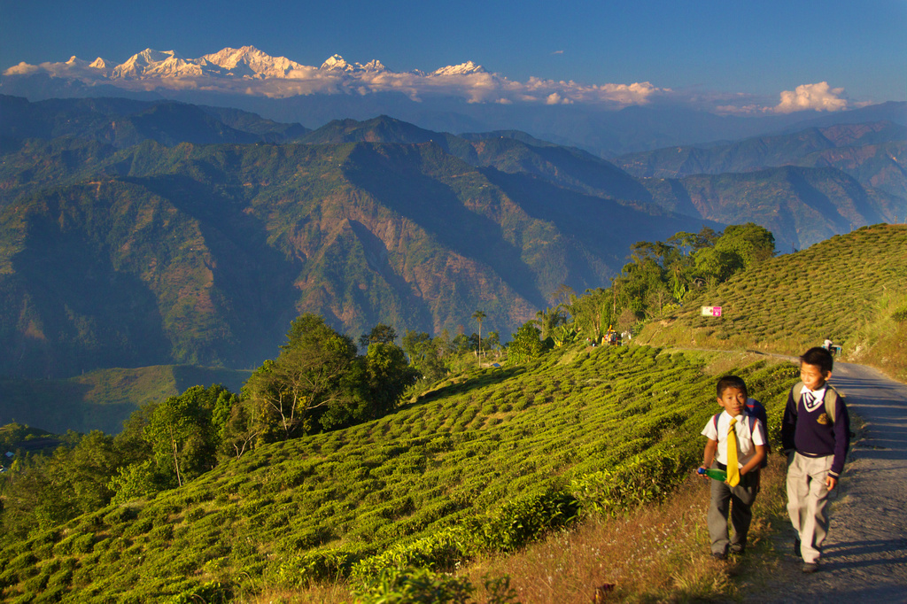
The spectacular landscape of Darjeeling, West Bengal. Image credit: Daniel Peckham via Flickr.com.

West Bengal is blessed with the magnificent Eastern Himalayan ranges in its northernmost part. The state's highest peak is Sandakphu (3,636 m) in the Singalila Range. It is no surprise that this region is generously sprinkled with highly popular hill stations, perfect for relaxing getaways in the heart of nature. These include Darjeeling, Kalimpong, Kurseong, Lamhatta, Lava, and many more. Many viewpoints along this region offer stunning views of some of the world's tallest peaks, like Mount Kangchenjunga (8,586 m). For wildlife lovers, there is good news. The Singalila National Park, located in this region, offers great hiking and trekking opportunities. The park is also home to some rare and threatened fauna, like red pandas and clouded leopards, which attract many shutterbugs from across the world.

Dooars

The Dooars is home to large population of wild Asiatic elephants. Image credit: Jonoikobangali via Wikimedia Commons.

Meaning "doors" in the local language, Dooars in West Bengal truly lives up to its name. It is the gateway to breathtaking landscapes and rich biodiversity. The Dooars region, including vast alluvial plains, stretches from below the foothills of the Eastern Himalayas to the Brahmaputra River Basin in West Bengal. Within this region are some of West Bengal's most precious forests, including the famed Jaldapara and Gorumara National Parks, the Buxa Tiger Reserve, and the Chapramari Wildlife Sanctuary. The picturesque landscapes of the Dooars, encompassing gorgeous rivers, dense forests full of wildlife, spectacular waterfalls, and lush hills in the north, all make the region a tourist magnet. Of course, one must mention the many tea gardens that also carpet the landscape and provide a relaxing getaway to those looking to spend some cosy but less wild time in the heart of the Dooars.

Ganges Delta

A beautiful scene from rural West Bengal in the Ganges delta region. Image credit: Pritam by PixaHive.

West Bengal is gifted with fertile lands, and the massive Ganges delta in the state's south (that also extends into neighbouring Bangladesh) constitutes the gift. The river deposits sediments as it flows downstream towards the Bay of Bengal, branching off into its many distributaries, forming a fan-shaped delta at its mouth and a labyrinth of wetlands, lakes, river channels, and floodplain areas. It is here that some of the state's largest and most thriving cities, including its capital, Kolkata, are based. There are also many quaint towns and villages along these rivers that can be visited for their rich history, vibrant cultures, and, of course, scenic river views. While the Sundarbans mangroves can also be considered part of this delta, it deserves special mention.

Sundarbans 

A Bengal Tiger checks out the conditions before getting into the canal at Sundarban Tiger Reserve, West Bengal, India. Image credit: Soumyajit Nandy via Wikimedia Commons.

The Sundarbans region of West Bengal is truly one-of-a-kind in the world. While mangroves occur in many parts of the world, this is the largest cover of mangrove forests, stretching into the neighbouring country of Bangladesh. What makes it truly stand out is the fact that this area is home to swamp tigers, the only mangrove forest with wild tigers living in it. What more? Sundarbans is where the primitive fear of people comes alive. The tigers of the Sundarbans are known to prey on people. Here, in almost every village, you will hear stories of tigers attacking villagers when they enter tiger territory to collect honey, crabs, or fish. To the people of these villages, however, tigers are much above them, and they prey to their Goddess Bon Bibi to protect them from the wrath of Dakkhin Rai, a tiger-like mythical figure. West Bengal is indeed blessed to have such a unique ecosystem in the Sundarbans. A large section of this mangrove forest has thus been declared a national park. The Sundarbans National Park is also a UNESCO World Heritage Site.

Bay Of Bengal Coastline

The beautiful beach at Mandarmani, West Bengal. Image credit: Mum321 via Wikimedia Commons

Now, we arrive to southernmost West Bengal, where we have a series of simply gorgeous sea beaches for visitors to have a memorable beach vacation. Many beach towns like Digha, Mandarmoni, Tajpur, Shankarpur, Bakkhali, and Udaipur dot this coastline, allowing visitors to relax on their sunny beaches and enjoy water activities like swimming, boating, water sports, and more.

With so much more, West Bengal is sure to give visitors memorable vacations while exploring its many stunning landscapes. Each of these regions has inspired its own distinct culture, which enhances the lure of these destinations for visitors. So, why wait? Come and explore beautiful West Bengal.